


cap Garonne

chrifor
User
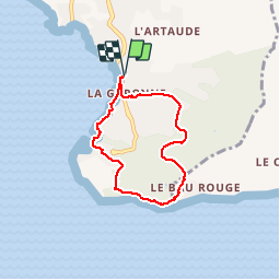

Length
5.9 km

Max alt
113 m

Uphill gradient
155 m
Km-Effort
7.9 km

Min alt
0 m

Downhill gradient
155 m
Boucle
Yes
Creation date :
2019-04-09 09:52:28.707
Updated on :
2019-04-09 09:52:28.76
1h45
Difficulty : Very easy

FREE GPS app for hiking
 SityTrail
IGN / Geographical institutes
SityTrail Plus
The world is yours!
About
Trail Walking of 5.9 km to be discovered at Provence-Alpes-Côte d'Azur, Var, Le Pradet. This trail is proposed by chrifor.
Positioning
Country:
France
Region :
Provence-Alpes-Côte d'Azur
Department/Province :
Var
Municipality :
Le Pradet
Location:
Unknown
Start:(Dec)
Start:(UTM)
257916 ; 4775450 (32T) N.
Comments